Friday, September 18, 2015

Seg 63 & 64 Last of the Last Leg (St. George, UT Filler Gap 9_12_15

Start
Fiddlers Cove Coronado  CA
 N 32.65228 W 117.15072

S-N mi  8.2
End

Mexico/USABorder  Tijuana Mexico
N 32.53446  W 117.12278

TrlLgth 12.8
Ride 20.8

Ride hr   3:33  AVS  mph   MXS 26.25 mph  DST    mi  WSW 15 mph  TMP 64-70    KCal 1666


Maze boys properly attired in TAVRTO tee shirts and hats  at Border Field State Park. The original goal was to get  to the border via Friendship Park but no one I spoke to seemed to know anything about Friendship Park.. Border Field State Park is a California state park that is at the southwesternmost point of the contiguous United States and the most southern point of California.


Last leg of TAvRTO from Fiddlers Cove on the Bay
 of San Diego to the United States - Mexican Border
After my getting lost and pushing our bikes through
a mile of soft sand we arrived at the Mexican Border 
fence. Geoff and I are actually three feet inside Mexico 
according to a Border Patrol officer. He claimed we
were further into Mexico at this point than had we 
made the 2 o'clock deadline to enter Friendship Park. 
Chris, Geoff and I left Long Beach an hour later than planned so naturally I was becoming very "Dad Like" in hustling down to the start point . Geoff made up a little lost time by speeding a bit on Pacific Coast Highway. We got to Fiddlers Cove on San Diego Bay about 10:30 am.. This start point just south of Coronado overlapped the latitude of the Trinity Trail that I rode in Ft. Worth, Texas. We unloaded the bikes and headed out for the most meaningful ride of the last leg---the Bayshore and Silver Strand Trail to the Mexican Border. Like the Canadian Border experience, we found frustrations at the southern border of the United States.  Chris and I rode the trail to thirteenth street in Imperial Beach. At that point we met up with Geoff and filled out empty tummies at a Burger King. It's not a good idea to fill up when the next segment of the ride was to ride up (200 feet of elevation within a block of overdosing at Burger King. Needless to say, the Old Man couldn't['make it up the first hill and had to jump off and push. Somehow I was able to make it up a similar hill by putting Rudy (my bicycle's new name) in its lowest gears (24) and cranking by standing up. After a mile or two of uphill climbing at Beyer Blvd.and then Dairy Mart Road  we were gifted with several downhill miles---my kind of biking! As official guide, Geoff drove ahead of us locating the proper turns to get to the border. It was good that he led us so we could pump hard without needing to stop to confirm directions. We needed to be a Friendship Park before two o'clock. By the time we met up again it was only fifteen minutes to make it to the park. Panicking that I wasn't going to make it to Friendship Park, I hailed down a Border Patrolman and asked him about Friendship Park. "oh, Frank left early today, the park is closes". "WHAT!!!" I shouted. I have ridden my bike three thousand miles from Canada. You telling me I can't make to the border?" 
The Border Patrolman is telling Chris and me that Friendship
Park closed early and the only way to the border was going to 
the beach and then walking south along a couple miles of  
beach.  Going that way turned out to be the best route. 

Chris and Geoff came up and started talking to the patrolman. Somehow I picked up that it was still possible to get the border by hitting the beach route. I thought I knew where this route was so I pumped my butt off riding horse, bike and trekking trails toward the ocean, but because the whole area was covered with eight foot bushes, I could not see where I should go. I was lost, damn it! Geoff bailed me out once he figured out where I had gone. A group of people on horses helped reorient me as well---although reluctantly. Horse people don't like bikes because bicyclists apparently spook the animals when you ride by them. The proper etiquette is to give the horse the right away. Because riders tend to only walk their horses, it makes more sense for the biker to ride ahead of horses. So that is what I did, not only for the horse's sake but also work off a bit of anxiety that had been building in me since our late start leaving Geoff's house. After thirty minutes of  stress, I could see a path heading toward the ocean. 

When horses tromp on bicycle paths, the horses win. 
When they poop, they win again. Bicyclists don't much care 
for horses on the trail and the horse folks feel the same 
about bikes. In all the TAVRTO riding across America, I 
only dealt with horses a few times in all the
Unfortunately the last half mile of this trail was extremely soft sand, primarily due horses tearing deep holes in the the trail.  That meant more bike pushing but thank goodness not as strenuous as False Cape State Park, in Virginia. Possibly because this trip was end of TAvRTO, and I was pretty "pumped-up" knowing I had completed my goal of crossing America, north to south, on trails only. The border fence was intimidating and seeing patrolmen watching us gave me the "willies". But I was done. I owe the battle. I think I am the only one to achieve this feat following the TAvRTO. At least I am going to claim it so. 


Looking south from the beach toward Tijuana
The Border Patrol sat in a vehicle to watch us
until we headed away from the fence. I didn't
want to inflame them by taking a picture while
they sat there, so this is after they left.
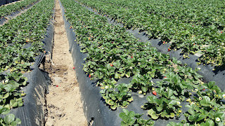
It was Mother's Day so Chris wanted to stop and get some freshly picked strawberries for Connie. Not far from Border Field State Park, we found a farmer selling strawberries. They were big, juicy and full of flavor. So Connie had a special Mother's Day and other than a seven mile "filler-gap"trail in St. George, Utah, I was done, finished---"el completo". What a great feeling. 

FILLER GAP RIDE IN ST. GEORGE, UT


Although I made it into Mexico, there was a seven mile stretch of latitude that I needed to ride when Chris and I could not finish the False Cape State Park trail (see Segment #37). Luckily a trail along Virginia Creek in St. George, Utah gave me the latitude (37.09889 - 36.99621) needed to fill the only gap left in my border to border trail ride.

Segment #62 Sea Watch Monarch; Salt Creek & San Juan Creek Trails

Start
Dana Point & / Capistrano  CA
N 33.49604  W 117.71073
N 33.47255   W 117.67958
S-N mi 2.7/0.8 = 3.5
End

 Dana Point & / Capistrano  CA
N 33.59589  W 117.88179
N 33.46122  W 117.67831
TrlLgth 2.8/1.1 mi = 3.9
Ride 5.4/2.2. mi = 7.6

Ride hr   :27/:20  AVS 7.1 mph   MXS 18.5 mph  DST  5  mi  WSW 9 mph  TMP 62-65     KCal 209

Chris and I are ready to ride 2.5 miles to ocean on the Monarch
Trail in Dana Point. We rode out and back on this short ride.

Both the Sea Watch Monarch and the San Juan Salt Creek Trails are short. In fact, if I had not needed the pittley bit of latitude they offered and I didn't want to drive to hell and back to find similar latitudes, I would not have bothered to plan and ride these trails. One thing that caused me to select them was the desire to get back to an area I enjoyed to visiting in the seventies when I taught at UCLA and completed a speciality in Periodontics. Distant relatives, Joe and Carl lived in Dana Point. They were very nice people and lived up in the hills overlooking the ocean and marina. Connie, the boys and I took several trips to Dana Point from where we lived in the San Fernando Valley. Back then there were open lots for sale including one directly out the back side of the Caldwell's property. I remember how they stewed over the idea of buy the lot for $5,000. $5,000!!! Gosh I wish we would have had to money to buy that lot. Today the lot with small home like the Caldwell's would sell  for at least $3,000,000. Riding my bike around their home, brought back the wonderful  memories of visiting Dana Point. Chris and Geoff didn't remember much about those days 
Chris and Geoff silhouetted against the Pacific Ocean 

other than pictures of the family with my Hippie Era haircut, actually a no cut haircut. Those were the days of bell bottom pants, platform shoes, head bands among other things.

Those were the days for the Maze family to have a pet. So the boys and I went to a pet shop in Chatsworth and bought a fluffy black cockapoo, giving her the name Pepsi. But like most puppies, Pepsi loved to dig. Did I say dig. I ment EXCAVATE! I had invested numerous hours and dollars redoing the back yard with a sprinkler system, grass, rose bushes, trees, perennial flowers and so on.. How nice the yard looked until digger girl realized that she could have so much fun displacing everything I had labored over for months and months. The dog has to go I told Connie and the boys. At first I tried to sell Pepsi with an add in the newspaper and word of mouth. A few people came to look only to say, "this isn't a Cockapoo, look at those big feet! So back to the pet shop I went. This time a pet shop just a few blocks down the street. I wanted to get a second opinion about whether this dog was a Cockapoo or a Crockapoo.
This pet shop owner was upset at the fact that the other pet shop had misrepresented the dog and said they would find a good home for Pepsi. The good home was at Sally's house; a animal loving lady that took into animals. Connie volunteered to take Pepsi to Sally. That was my mistake. Connie had just read James
Pepsi is anxious for me to take this picture so she can
chase the tennis ball I have in my hand. She was a good
retriever as well as a collie and many many other breeds
Herriot's All Creatures Great and Small. either that book or her own innate love for animals turned her into a miserable mess over having taken Pepsi to Sally"s. She cried herself to sleep. When I went to the bathroom in the early morning, there was a letter laying on the sink top. I started reading the letter and realized Pepsi was too important to a happy family to be so cruel to give Pepsi away. I melted and told Connie to go to Sally's and get Pepsi. As soon as the sun rose, Connie called Sally's and told her she was on her way to get the dog. Somehow Pepsi sensed she was in trouble so I don't remember her digging anymore. She was a wonderful pet for which I am forever thankful that Connie wrote me that note that got Pepsi out of the dog house for thirteen plus years. She was the only dog we had for any length of time. We tried a replacement dog named Frankie but Frankie was genetically wired to be a hyper hunting dog; he was part springer spaniel. So after a few months of chasing Frankie into the woods, we gave him back to the animal shelter in hopes someone that had a large lot with fence or a farmer needed a dog. After Pepsi and Frankie our dogs days were over and we took in a couple cats as our family pets.


Segment# 61 Seal Bch-Balboa-CoronaDelMar-CrystalCoveStatePK via Bch Trls/PCH 5_5_15

Start
Seal Bch, CA
N 33.74661  W 118.11269
S-N mi 13.3
End

Crystal Cove State Park
N 33.59589  W 117.88179
TrlLgth 23.6 mi
Ride 31.3 mi 

Ride hr   4:10   AVS 7.4 mph    MXS 28.5 mph  DST  31.3  mi  WSW 8 mph  TMP 61-63     KCal 1519

Although I did not ride from Long Beach to Crystal Cove in one ride, logistically it made more sense to jump on the Seal Beach Trail at the Huntington Beach Pier and ride to Crystal Cove through Balboa and Corona Del Mar. After Chris flew in from Iowa, the three of us I rode from Geoff's Long Beach home to Huntington Beach Pier.   
I planned segment # 61 as one long trip from Seal Beach to Crystal Cove State Park. However, I decided it would be nice for the three Maze's to ride together on an open day (Friday).  So I modified my plans and bypassed the Seal Beach to Huntington Beach.Trail segments (~11 miles) and. hauled my bike to Huntington Beach Pier.  From there I pedalled my Trek Fuel 7 southward to Newport Beach, Balboa Island, Corona Del Mar and finally Crystal Cove. Most all the trails I rode along California coastline were shrouded with a marine layer until noon or later, then like clockwork, the sun would poke out its head out and the temperature would jump upward ten or more degrees.
I am riding the Crystal Cove Trail next to Pacific Coast High-
way. When the bike trail ended about three miles from here,
I rode the bike shoulder on PCH. Not a safe way to go.
Most morning rides the temperatures were in the mid to lower sixties. With the wind blowing across the water, the "feels like temperature" felt like it was colder than Iowa in the month of May. This meant there weren't many bicycle, running, skate board or other trail activities on this trail.or for that matter, any trails I rode approximating the ocean. It is a different story when it warms up in the eighties, especially on the weekends when many trails are overpopulated. I am glad I avoided most of the trail congestion by riding in the morning and as little as possible on the weekend.

I had to download this picture off the internet because my
camera won't let me download the neat video I took. There
is something about crashing waves and cameras with me.
The most picturesque of the California beach trails I rode was the ocean, beach and cliffs at Crystal Cove State Park. I tried to insert a video here that I took of the cliffs and beach, but there was a problem downloading. While I watched the waves crash into the cliffs. I brought back memories of the beauty of the Azores Portugal where I was stationed in the US Air Force 1971. I was really into photography along with a couple other guys from the Hospital Squadron. We would go on picture shoots of flowers, cobble stone roads, white adobe homes, ocean ways and so on. One shot I got was of a man dressed in his Sunday best walking his pig in the village streets. This hog was a lot more manageable then the ones we had on the farm. The gentleman had one back foot tied with a rope and used a long stick to poke the porcine back on track or to stop it from rooting up someones garden. The picture I took with him and his pig was a favorite of mine. Years later when I displayed it in my photography class at UCLA, all I could get out of the instructor was, "interesting snapshot".  Once and only once I took Chris on a photoshoot along the shore where the waves crashed with dramatic force into the huge black volcanic rocks. Chris was trying to catch crabs scooting amongst while I was firing the camera at every wave that looked interesting. The waves had lost their steam about fifty yards ahead so I had no real concern about Chris or me getting wet. However, a rouge wave decided to roll in just when we were ready to leave. Boom! I got blasted and lost my balance and fell between the rocks. Chris fell deeper into the rocks than I did. I scrambled to assure he was alright, He thought it was fun to get ballasted but I was scared out my wits. Once I realized we were not hurt---just wet, I realized my camera was gone. It was ripped out of my hand along with the strap around my neck. I know I took some incredible pictures that day. But not unlike the fish that got away story, the damaged camera and wet film left me without an image of the coolest waves and rocks that I will ever see.

It was quite a trip down to Crystal Cove from Huntington Beach,  especially when I consider how lucky I am to still have  my Galaxy Note 3 ("Smarty Pants"),  Nature called when I was riding pass West Newport Park. How fortunate to find a porta potty by the handball courts. It looked like the gentleman handball league was having a tournament. The courts packed and numerous fellows hanging around. I shot into the potty and unfortunately shot out faster than I should have, I left Smarty Pants in the potty and didn't realize I had done so until I got to Harbor Island nearly three miles south of the park. Given it took me twenty minutes or more to realize my mistake and another fifteen to twenty minutes to get back to the park, I imaged that I was now smart phoneless. But I was handed a Salt Lake City airport experience and luckily found my phone right where I laid it. I guess the handballers didn't have need for a smart phone or they figured it belonged to one of the guys playing. Whatever, I got the phone back. To me it was a miracle comparable the time I left my wallet in the restroom at Salt City International Airport, only to get it mailed back to me in Iowa with all four hundred dollars intact. I attribute that miracle to descendants of  Joseph Smith (LDS). I confirmed the Mormon connection when I phoned the airport employee in Salt Lake. I have a soft spot for Mormons but not enough to convert. If I did, my dad would roll over in his grave a few more times.

Back to TAVrTO. The reason I remembered Smarty Pants as soon as I did was I had asked a local gentleman for directions to the ferry. As he was explaining directions directions he stepped backwards into the street, on line to get clipped by a speeding car running a red light. He grabbed the handlebars of my bike and pulled just enough to avoid serious injury. He was forever grateful that I was there and I had control of bike---"you saved my life,"he yelled. He wanted to have a picture of us. He didn't have a camera so I said I would take a "selfie". That's when I realized my blunder.
The Balboa Island Ferry is pulling into its landing site on
Harbor Island. Two cars (red & white) are visible on the
ferry. The ramp in the middle of the picture is where other
riders and I wheeled  our bicycles on and off the ferry. The
ferry ride was was a short yet enjoyable trip. 
After I rode back and got Smarty Pants, I rode around looking for the "lucky-one" to take a picture of two "lucky-ones." I couldn't find the Lucky One so I headed to the ferry to cross from Harbor Island to Balboa Island. The young man helping old folks like me board the ferry was especially kind so I passed forward my gratitude for him and Lucky One with a five dollar tip. Everyone was happy!

After reaching my target latitude and riding back to El Morro Elementary school to meet a taxi to take me back to Hunting Beach. The cab driver was a interesting fellow that seemed interested in my cross country trip. He wasn't a fan of Uber so I heard a litany of Uber comments; mostly "down in the mouth"  ones.


Segment # 60 San Gabriel River Trail Duarte-Whittier Jct. 5_4_15

Start
Duarte, CA
N  34.14138  W 117.93481
S-N mi 9.4
End

Whittier Jct,CA
N 34.00696  W 118.06916
TrlLgth 15.4 mi
Ride 18.4 mi 


Ride hr   1:54    AVS 9.9 mph      MXS 19 mph     DST  18.4 mi    SW 4-5 mph   TMP 64      KCal 1309


The grand girls with parents and grandpa in tow, heading to
Tincher ( I liked to tease that it was Tingcher or Pincher) to 
learn all kinds of stuff to keep grandpa on his toes. 
After hoofing to school with the Long Beach gang. I loaded up to drive to Duarte for a solo ride on the San Gabriel Bikeway. Geoff and Kayoko were back to work so it was time for me to ride on my own again. Reviewing Trail-Link description of the trail alerted me to two issues; that turned-out to be non-issues; reported by other riders of the trail. One was a dark tunnel and the other was unseemly contact with transients living under the bridge on the 10 Freeway. The tunnel I rode through on this trail was not like other long tunnels, for example the Elroy to Sparta Trail in Wisconsin where you must dismount and have a decent flashlight to safely pass the through over a mile long pitch dark tunnel. I didn't need a light for the San Gabriel Bikeway. The transient encampment was of no concern to me either since most of the inhabitants were on the streets of Los Angeles working on handouts.. I was surprised to see a large flat screen television blurring away in what I now call Transient City. Where did the power come from? In addition, there were some other unique oddities like an organized person that had their clothes neatly organized and hanging from what appeared to be racks from a clothing store. 
I'm ready to ride across a bridge the connects the east with
the west side of a waterless San Gabriel River. Just behind
me is 
where I parked ( Ecanto Park Duarte, CA ) to begin. 

I was particularly fascinated with what was in place for water preservation and control on this river. At the northern end of the trail, near Irwindale, the Santa Fe Dam serves as a major holding area for excess water. There should be a time when flood control will be needed but with multiple years of drought and with one of the driest years on record in 2014-2015, It appears the Santa Fe Dam will just be sitting there for another year or two. I hope so, because Geoff only lives a block from the lower end of the San Gabriel River. 

I exited the bikeway at Beverly Blvd. and called a cab to get me but to my car at Ecanto Park. As I sat at the Pico Rivera Recreation Center, I realized I was only a mile or two from Montebello where I practiced periodontics in the offices of my fellow periodontal resident, Bill Matoska and his partners Joan Otomo and Mike Neuman. I had already called a taxi so I needed to stay put but I thought I would ask the driver to take me by the office. Unfortunately the cab driver could only speak a few words of English so I decided not to try getting him to take me two places.    
The San Gabriel River Valley has been the heart of gravel mining for nearly a century, especially when the automobile became king of transportation in southern California. 
There are not as many mines today as there were in the fifties and sixties but this operation near North El Monte was abuzz with activity. I was struck by the azure color of the water---pretty! 
                                                            

Seg # 58 & # 59 Ojai Valley-Ventura River & Port Hueneme Bch Trl 5_2-3_15

Start
Ojai, CA
N  34.44574  W 119.24682
S-N mi 19.7
End

Oxnard,CA
N 34.16283 W 119.22607
TrlLgth 26.2mi
Ride 27mi 

Ride hr   2:53    AVS 11 mph      MXS 21 mph     DST  27 mi NW 15-20 mph   TMP 62       KCal 1992

The northern start point was Ojai and the southern end point was south
 of  Oxnard. The Port Hueneme Beach Trail is the small trail south of Oxnard
We got to Ojai from Ventura about 6:30 p.m. where I rode about four miles of the north end of the trail. It was getting dark so we started looking for a place to stay. But like most destination areas, the motels were all full. So we drove to Ventura for a great meal at The Lure  located in the heart of downtown. I had to have seafood, and that I did---the best crab ever! After a deep restful night of sleep at the Comfort Inn, we loaded up and drove to the spot I had ridden to the evening before. The upper end of the Ventura River trail is picturesque but not so pretty as we got closer to Ventura. Oil drilling is king along the lower end of the trail. A top ten trail at the Ojai end morphed into a mediocre trail at the Ventura end. As we rode further, the Ventura Beach Trail that paralleled the ocean and beach upped my trail ranking number to somewhere in the top ten trail.  Part of the ride was south along Mandalay Road and South Harbor Boulevard to the pick-up point at Albacore. Because it was Sunday morning, I saw more riders on the upper half of the trail than I have witnessed on most trails. I am guessing I saw up to seventy-five bikers pedalling their way to good health and a delicious  breakfast or a carafe of wine.
Geoff and me at the north end of Ojai-Ventura River Trail.
A couple school teachers were so kind as to rescue me 
from  my ill attempts at a "selfie". I couldn't get the hills and 
valleys in the picture but they did. Thanks ladies. 
 background, Thank you ladies. 

 Part of the trail had a rough surface. I call it "pebbly" in that it had lumps, likely rocks impregnated in what a appeared to be asphalt. The vibrating surface caused shaking of every bone bone in my body. It would have been nice to have a fair warning before I hit the rumble strip-like surface.. I don't know if this was a mistake or some just had some extra asphalt left over and dumped it without proper trouling. Tree roots under the trail added to the shake factor. Geoff met me at the end of the route in the marina at Albacore.

We headed to the start point north of Port Hueneme near Carty Park. Since the Port Hueneme ride was such a brief trip and nothing particularly "sticks out" about this ride, I decided to add Segment # 59 (Port Hueneme) to this post. You would think that a former photography nut would have at least taken one picture. The memory bank images send to this brain did not register anything. nor did the Samsung Note 3 I have been using the past two years.I did a lot of black white photography in the 70's through the 90's.with my own darkrooms. The best darkroom I ever built was in Ames. I had about every toy and tool a person needs to do great things. But when digital photography came along and when black and white roll film became more difficult to find, I lost interest in photography. Now I just shoot a bunch of pictures and let the automatic settings do their thing. It is a creative art like it used to be when I was stationed in the Azores. That's where I really got excited about the art of photography. My air force buddies Craig and Steve would invite on photo shoots all over Terceira, the island where Lajes Field was located. I took hundreds of images of rock formations, waves crashing into the shores, Portuguese children playing and their elders doing such such bizarre things as dressing in their Sunday best and then taking their favorite pig for a stroll through the island's main city, Praia. One of my favorite pictures was one of a Portuguese framer that  had his pig loaded in a trailer. I imagine the pig was going to slaughter. Both the farmer and the pig had the same facial expression. I thought it was a great picture, but a mucky-muck photography teacher at UCLA thought it was a joke that I had put up this picture as a work of art. I never forget his words, "interesting snap shot Mr. Maze". Snap Shot! I dropped the class that night. To hell with'em if they can't recognize talent.

Seg #59 Port Hueneme Streets and Beach Trail
Start
P Hueneme(N), CA
N  34.165139  W 119.185969
S-N mi 1.7
End

PH Beach (S),CA
N 34.140538 W 119.19059
TrlLgth 2.2mi
Ride 2.7mi 

Ride hr   :33    AVS 11 mph      MXS 18 mph     DST  2.7 mi NW 15-20 mph   TMP 65       KCal 292

As best as I can remember the trail in Port Hueneme was mostly concrete. A smooth ride in  mostly residential areas. The US Navy has a large base here called the Naval Base Ventura County. The base was restructured in 2000 by merging the Naval Air Station Point Mugu with the Naval Construction Battalion Center Port Hueneme. I didn't get near the base but I bet some of the young men I saw on the trail were Navy personnel. numbers over 19,000 of which nearly  2,600 are Seabees. Seabee training started here in 1941 and remains the major such training facility on the west coast. Keep us safe seamen!

Geoff and I were on schedule and ready to head back to Long Beach around 3 p,m. Lucky for me my granddaughters,  Kari and Kiara,  gave up their bedroom so their tired-out old grandpop could catch up on some sleep.


Seg # 57 Santa Maria/Nipomo-Orcutt Trails + streets 5_2_15

Start
SE of Orcutt, CA
N  34.84863  W 120.42294
S-N mi 12.5
End

NW of Nipomo,CA
N 35.02775 W 120.50792
TrlLgth 20mi
Ride 26.8mi 

Ride hr    2:00     AVS 13.3 mph          MXS 36 mph         DST  26.8mi       TMP 64        KCal 1208

My route should have been about twenty miles but finding my 
way on the planned route was a damn headache.
 siThis is the second trail I rode backwards, i.e. south to north. The ride included trails, bicycle friendly streets and trek across open country through a dry river bottom. In planning this segment I had more notes as to how far I should ride in a direction and where I should turn. The fact that I got lost at least three times made it frustrating a bit scarey. It would have been best that Geoff would have stayed with me and helped me stay on course. But because "Smarty Pants" (my Samsung Note 3) ran out of power, I was just out there trying to get back on track. The most damning part of the ride was where I needed to parallel Highway 101. It appeared on Google Earth and Google Maps that I could take the Santa Maria Levee Trail northward and then take a path along 101. But instead of a rideable path, I was pushing and carrying my bike like a Cyclocross athlete through soft sand and strawberry fields to get to the other side of the Santa Maria River (no water-bone dry).
This was the trail I used to get to the other
side of the Santa Maria River.
 Not only was it a challenge to get to the opposite side of the river bed, but I came upon a bunch of drunks in what appeared to be a shack for farm workers. They were quite boisterous and likely would have given me crap for crossing their strawberry fields. I hid out by some trees and when I saw a semi-truck pulling in their line of site, I scampered to the truck and jumped on my bike. I heard the roughens yell but didn't here what they were saying. Anyway I got out of perhaps a bad situation without a scratch. As I pedalled north and passed more strawberry fields, I thought fondly of the days on the farm and being assigned to multiple fruit picking jobs. Strawberry picking was a joy because at
I couldn't help myself from helping myself to these tasty gems
 least half of every picking that I did on my own recognisance, was in my stomach and not in the basket. There were many other picking assignments with apples being the biggest assignment. On the Carroll farm we had a little over ten acres of peak producing trees. The Whitney crab apples were the first apples to be ready. They followed the red, yellow and Montmorency cherry and the black raspberry pickings. As we moved into early August, the other apples were maturing and needed picking. Mom picked more fruit than the rest of us. Sometimes mom and two or three of  the boys would attack a tree and have it disseminated of fruit in an hour. Other times one or two of us would peddle along at a snails pace, plucking the ripest and largest fruit. One apple picking incident  that hounds me to this day, was a time when mom had three boys (Don, Dick and myself) helping pick the Wealthy apple tree near the grape vines and closest to the house. I saw mom leave the tree and go into the house but didn't see her come back. We boys were chatting away like canaries. Thinking, or maybe not thinking at all, I referred to my parents as the Old Man and the Old Lady. No sooner had my vocal cords released these disrespectful words, when I heard mom say, "Glenn, that is no way to refer to your parents?" I hope I apologized, but for some reason I still feel guilty for using such disrespectful language. Maybe I didn't apologize. Damn me! The heart of the apple picking season was October and one year when all my brothers had flown the coup, just mom, Ed and I were available to pick a bumper crop right before a freeze would claim an otherwise perfect season. I knew it was extremely important that I help. Mom asked me if she could approach school to stay home and pick apples. I was fine with skipping school but what about football practice? My dad took care of that issue by driving over to Coach Macomber's house and informing him I was missing football practice and it better not affect my starting position. We got the apples off the trees and piled on tarps. The mounds of apples throughout the orchard was a beautiful shade of red. I think we were successful because a few neighbors helped with a bushel or two and my dad actually picked too. His role had always been to prune, bud, and spray the trees. Not to pick. Oh, an another thing---patrol the crop! He would walk the orchard with a twenty-two rifle or a double barrell shotgun, he would fire in the air to scare away apple stealers from the town's renegade population. The only lawsuit potentiating occurrence, post-gunfire, involved a kid getting caught in the fence and then failing down a steep embankment of the ditch. only to break his arm. The fact that this young man was the son of a lawyer, makes it even more likely that my dad would have been prosecuted in this day and age. We never heard a word for the perpetrator or his dad. I liked those days. A major downside of raising apples involves controlling the pests. Back in the days when I was assigned to driving the tractor while my dad sprayed the trees, no one was concerned about the hydrocarbons in the spray. My dad would wear glasses, a cap and overalls but no respirator or anything to cover his face and hands. It took nearly fifteen years for the side-effects of the pesticides to raise its ugly head. In the fall of 1966, my dad started to complain of difficulty breathing. I was in college at the time. My folks had sold the Carroll farm and my dad took his half of the proceeds to buy a larger orchard near New Market, Iowa, This is when the respiratory issues were peaking and the closest doctor in Clarinda had no clue why my dad was feeling like he was suffocating. Of course the usual avenues of diagnosis, e.g. lung cancer (my dad never smoked) and heart disease were evaluated many times with no conclusive findings. So, as is the case in many states and definitely in Iowa, mystery  cases are sent to the state's primary teaching hospital, in this case the University of Iowa Hospital and Clinics. I was a second year dental student so I would stop by his bed on my way across the Iowa River to the dental school and again on my way back from a long day of lectures and tooth related laboratory courses. Initially dad was being treated by a mucky-muck pulmonologist but when it became clear the costs were going to be astronomical, he was parlayed to  care from residents and interns. I will never forget Father's Day 1969. A patient called me about five in the morning saying my dad had a rough night and he was worried that he was being ejected from UIHC because there was talk that no one had a reasonable idea what was wrong with my dad, especially when it was determined his oxygen exchange at the deepest part of the lungs was only twenty per cent of what it should be. I got to the hospital shortly after I received the call. My dad did not seem to recognize me and was rolling and thrashing in his bed. I tried to talk with him, but it was just moaning and rumbling coming coming from his lips. The assigned intern came in and said he would need to sedate my dad because his anxiety was depleting oxygen faster than the oxygen from the nasal cannula could get it into his lungs. The intern administered ten milligrams of diazepam (Valium) with minimal affect. And then he gave dad another ten milligrams. Knowing what I now know using diazepam for dental sedation, I believe twenty milligrams were too much. Anyway the next thing I knew, they brought a gurney into the room and told me to get away. I was confused and surprised at the same time. Because when I looked back at his bed, they were lifting my dad on to the gurney and my dad had a smile on his face. Almost as if he was enjoying all the attention he was getting. I had no idea how bad things had become so when the head resident called me into his office, he started talking about how sorry he was. I thought is he sorry because they were running out of solutions, or because they wanted my dad to be moved to a nursing home. Whatever I was thinking, it wasn't that my dad was dead. "Jesus Christ!" I said.--- "my dad is dead?" Really? Since he was just sixty-three and had no known maladies, it was a major shock to me. How could he have a smile on his face and be dead? Because the hydrocarbons in the spray bind up the oxygen receptors on hemoglobin, my dad basically suffocated and I am convinced Valium used in excess speeded the process. At least I don't think he suffered. I would like to "check-out" with a smile myself. I guess I got windy about about my dad because today is Father's day.  

My smart phone ran out of power and I was unable to contact Geoff. Luckily I came across a cell phone business call Boost. I was pretty tired by the time I got there so I asked if the ladies behind the counter if they could give my phone enough charge to make a phone call. Not only did they charge my phone but they loaned me  their phone to call Geoff. He was only a few blocks away so he drove over to Boost and led me for five or six blocks to the planned northern pick-up point. After hanging the bike on the carrier, we headed to Ojai on a better road than highway 58. Thank God


Seg #56 San Luis Obispo Railroad Safety Trail & city streets to Airport; 5_2_15

Start
North
RFK Library Cal Poly; SLO, CA
N  35.30303  W 120.66512
S-N mi 4.7
End
South
SLO  County AirPort
N 35.23584 W 120.63298
TrlLgth 6
Ride 7.8mi 
Ride hr   45min     AVS 13 mph          MXS 25 mph         DST  7.8mi       TMP 62-70        KCal 456

In order for the  latitudes to overlap, I often needed to ride city streets as was the case with San Luis Obispo. Only the
short SLO Railroad Safety Trail was used in this ride.  

After a solid seven hours of sleep and a typical continental motel breakfast, Geoff hauled me to the Cal Poly SOL campus where I started riding from the Robert Kennedy Library on streets and sidewalks. after a couple of miles I hooked up with the Railroad Safety and the Robert Jones trails. Visiting San Luis Obispo was a special event for me given we came close to starting a periodontal practice here after I finished my residency in 1977. At the time San Luis Obispo's population was something like thirty-five thousand and a new periodontist had just started his practice. Given there needs to be a 50:1 (50 K population for one  periodontist), I decided to not establish a practice here. Oh did I mention that Connie cried in happiness because where she preferred to go, Ames, Iowa, won out. The downtown area was still familiar even though it was thirty-nine years ago since I spent any time here. The Madonna Inn remains the place to stay and eat. We didn't have time to check-out the inn because we realized that Geoff had a tire go flat while it hung on the bike carrier. As luck 
Ira"s Bike Shop is the place in Arroyo Grande to go when it comes to repair
and customer service in the world of bicycles. Ican't tell you how impressed 
I was with the owner's speed, accuracy and affordability.. Thank You! 
would have it we found IRA's Bike Shop quickly. What a nice fellow this Ira dude. He inspected the tire and showed us dozens of cactus needles sticking through the tire and into the inner tube. In a matter of minutes he had the a new tube and tire on the rim. And, to make it more unbelievable, he charged me only $30 for everything. I hope my praise will bring the shop more business. Thank you so much!

I don't know why I felt so creepy with this bridge but I couldn't ride it. With people riding, 
running and walking. it wasn't safe trying to ride---especially dodging people.
After riding from the RFK Library on the campus of Cal Poly, I found the Railroad Safety Trail. At the junction of George Street is the northern access to the trail. There were many walkers and runners on the trail and the overpass bridge at the Amtrak station. A runner told me I needed to cross this bridge to get on the trail. But after riding and then pushing my bike up and down six levels, I realized I could have stayed on the east side of the bridge and connected with the SLO RR Safety Trail. 
I crossed this Amtrak bridge twice but realized I did't need to cross once.
Once would have been enough for me. 
There was something spooky about this bridge. Perhap it was because there were so many folks using it on an early Saturday morning. Again I pushed my bike up three levels and then down three levels to the bike trail. I had a pretty healthy breakfast and hydrated to the tune of bladder screaming. So after getting to a more isolated part of the trail, I jumped off my bike and dashed for the bushes. As I was blasting what appeared to be an empty beer can, the can moved. It moved more. Crap, "I am peeing on a homeless person", I said to myself. Once I realized my poor aim, I shouted my apologies and got the heck out of there as fast as I could. After I rode down the path a bit, I noticed in my rearview mirror two guys standing in the middle of the trail waving their arms. Sorry guys. Geoff was waiting for me at the San Luis Obispo County airport so no time was lost, in fact we were four to five hours ahead of schedule. Off to Santa Maria we went.