Tuesday, July 30, 2013

Segment #23: Frisco Highline, Wilson Creek Greenway Springfield, MO 7_25_13

Start
Willard, MO
37.304999 -93.42761
NS miles 14.7
End
Battlefield NM
37.09159,-93.40540
Trllgth18.8Ride 21

Ride Hrs 3:23
AVS 9.5
MXS 23
KCAL 908
Temp 86
El1088-1305
*These data are estimates; I rode my black Trek that no longer has a working computer

Trixie was first-rate in shepherding me to the comfort of the Comfort Inn and she splendidly found the trailhead in Willard, MO. Being so close to Springfield, I could not but try to contact one of my top ten residents, Jody Vance. Jody finished his periodontal specialty certification at Nebraska in 1994. Right after Dr. Kaldahl gave him his certificate, Jody jumped into a loaded moving truck with his car in tow. My guess is he drove all night to get to Springfield. This hard working young man jumped into practice feet first. I am so proud of his leadership; support of the dental profession; and dedication to his community. Not only did he blaze the bicycle trail
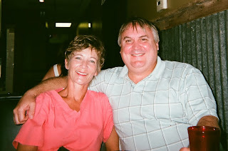
Jody with his Nebraska College of Dentistry classmate Marlene Feisthamel. These Cornhuskers keep Springfield teeth, gums and implants in excellent condition.
I rode, he was instrumental in organizing the Ozark Huskers. That's saying a lot for guy who grew up in Oklahoma.  His support of the Ozark Multiple Sclerosis Chapter is just another good guy thing this man fits into his busy schedule. Keep it going Jody!
  How impressing it was to see so many people riding the Frisco Highline trail. The trailhead parking lot in Springfield was packed and it wasn't even the weekend!  Unfortunately the Wilson Creek Trail doesn't connect with the Frisco Highline Trail so I had to do some creative peddling along the West Bypass, Republic Road and the streets of Battlefield. I was able to negotiate the traffic without a hitch to get to the Wilson Creek National Battlefield. The Battle of Wilson's Creek, August, 1861, opened the Civil War in Missouri. By the end of the war,
Over my shoulder, up by the lone
tree, is the restored farm home of
John Ray. Ray, his wife and nine
children along with an enslaved
woman and her four children and
a mail carrier all took shelter in
the cellar while the Confederates
used the home as a hospital.
 
Missouri had seen so many battles and skirmishes, it would rank as the third most
fought-over state in the nation. Many soldiers
hid and crawled through cornfields the farmers
in the area had planted. As a farm boy I was impressed that the battlefield was in prime shape with the corn tasseling over six feet---perfect for hide and seek guerrilla warfare. Despite the Union Army being 8,000 troops down to the 12,000 Confederates, the Union forces initially prevailed by using surprise attacks lead by General Nathaniel Lyon. But when Lyon was killed a day later, the Unionists retreated. Not until September, 1864 did the Union Army return. In the biggest battle of west of the Mississippi, the Battle of Westport, October 23rd, The Confederates were driven into Arkansas to never return.

When I was trying to establish my location on the Wilson Creek Trail, I came upon this work
of art, at least that is what I thought. There was no identifying plaque as to the name of the
piece nor the artist but I was intrigued and took this picture. When I ran into a local fellow at
least my age, I thought I would get the story. Well not only did he not know anything about a work of art in the area, he could not remember seeing this wall in the middle of no where next to the trail. Maybe it is left over bricks from Pink Floyd's The Wall? :-)

Sunday, July 28, 2013

Seg#22 Prairie Spirit Trail #2 KS 7_24_13


Start
Garnett, KS
38.40145 -95.252604
NS miles 7.9
End
Richmond, KS
38.28303,-95.24920
Trl lgth 9.6Ride 19.2

Ride Hrs 2:10
AVS 9
MXS 14
KCAL 1600
Temp 88
Elev 960-1130
*These data are estimates; I rode my black Trek that no longer has a working computer


Ride segment #22 was a feel good ride with pequeno vento (Portuguese: “little wind”--- hearkening back to living in the Azores while serving in the US Air Force) or humidity and plenty of sunshine. It tickled me to be able to complete unfinished latitude Geoff and I were unable to complete on Segment #16. Since I was alone, I needed to peddle up the trail to Richmond, Kansas and back to Garnett, Kansas nine plus miles each way.  The train station in Garnett is a classic.


Garnett, Kansas: This is one of the
nicest trailhead stops I have seen.
An awesome restoration

 The original railroad, Leavenworth, Lawrence and Galveston Railroad, built in the 1868 eventually went bankrupt due to the Great Panic of 1891. The Santa Fe Railroad then procured the right of way and operated the tracks for ninety years. In 1990, the KTC Railway Corporation bought and subsequently abandoned the rail bed. In 1992, the Kansas Department of Wildlife and Parks obtained title to the right of way and the first section of the Prairie Spirit Trail was built. Currently the trail is nearly sixty miles in length. Long range plans include joining the Prairie Spirit with the 117 mile Flint Hills Nature Trail and then connecting both trails to a Quad State Trail uniting four states,  Kansas, Missouri, Iowa and Nebraska.

Shorty after 5 p.m., I headed toward Springfield, Missouri for the Frisco-Highline Trail. Along the way I passed through Fort. Scott, Kansas. The town is quaint with eighteenth and early nineteen century buildings restored to their original glory.
Fort Scott National Historical Site today. The
post served to keep the peace and corral the
native Americans to the west side of the
Mississippi River. Heavy bloodshed occurred
The Fort was established by the US Army in 1842 to protect the Permanent Indian Frontier. Prior to the Civil War, Ft. Scott was a hotbed of controversy over the extension of slavery into new territories. Murder, rape, mayhem, robbery, arson and other hyenas crimes were committed by bold free-state, pro-slavery advocates in the name of the Cause. On January 29, 1861, Kansas entered the union as a free state but turmoil known by eastern newspapers as “Bleeding Kansas” continued throughout the Civil War. After the war between the states, the army pulled out of Fort Scott only to be called back in 1869 to deal with squatters  who forcefully opposed  the development of the railroad south of the military installation and the city of Fort Scott. The army became the scapegoat of problems between the squatters and the railroad, causing the troops to leave Fort Scott in 1873.  The development of the Fort Scott National Historical Site makes this area a destination point. I hope to return with Connie so she can enjoy the shops in the town along with the history at the historical site.


As I said before, I hate driving at night but that is just what I did. Trixie (the GPS Momma) was relied upon to get me to Bolivar, Missouri where I crashed a burned for a power sleep.
Even though Kansas is a flat state, there is tremendous beauty when the golden wheat contrasts with green trees and row crops. When I was on the farm, bales were liftable.
These two ton "porkers" require heavy equipment to lift, carry and stack. They are good for
hiding moonshine as we learned on the History Channel :-)


Tuesday, July 16, 2013

Seg #21 Hiway 12 Trl & Badger State Trl 7_11-12_13


Start
Middleton WI
43.19591-89.58140
NS miles 46
End
Clarno WI
42.51851,-89.64794
Trl lgth 52/Ride 52


Ride Hrs 5:40
AVS 17.9
MXS20.2
KCAL 4173
Temp 82
Elev 820-1115

What perfect weather for Segment #21. Mark, Donna, Connie and I headed out from Dubuque, IA and drove to north of Middleton, WI to find a paved bike path at the junction of highways 12 and 19. The nice thing was that 75% of the trail was downhill---a good warm-up, without the stress from hills and headwind. It was one of my top ten biking days ever, as far as ease of ride. Scenery and traffic noise kept the Cam Rating (see Cam and Cush names below) down to seven on a ten point scale. Low humidity kept the sweat beads from forming and the body cool. After riding the Highway 12 trail to Middleton, we loaded up the bikes and drove to the Lakeshore Nature Preserve, part of the University of Wisconsin Campus. A wordless sign at the gate displayed the ubiquitous NO Way Jose, showing an encircled bicycle image with a diagonal line through it. I was bummed out about my latitudes until I checked my GPS. It was clear I did not need to ride from as far north as Frautschi’s Point through the preserve. I made a note of the change in coordinates and we headed south toward Madison in search of the Blue Moon Bar on University Avenue.
Mark outside the Blue Moon in
pursuit of the Slimy Curd Motor-
cycle Club but "No Cigar"
The joint was minimally habituated likely due to the university students being off on summer break.  Mark was in hopes of meeting members of the Slimy Cruds Motorcycle Club that regularly meet at this bar. The bartender didn’t know that much about the group, a surprising response and eliciting a negative Cam Rating from me. After a sandwich and beer, we headed south on Highland Avenue to connect with the Southwest Commuter Trail and then Badger State Trail. We needed to ride to Belleview, ten miles, to complete half the distance of our two day ride. As we rode south the trail changed from paved to crushed limestone. Mark thought we could ride a bit farther to New Glarus to meet the ladies so he hailed down a bicycler coming toward us. This cyclist looked like Mark but wasn’t as sharp as Mark when it came to directions, confirming Cush’s Theorem. Back in our college days at UNI, we had given each other biblical names. Mine was Cam and his was Cush. Cush’s Theorem states that no matter who you ask for directions, there will be significant details excluded, thus resulting in not arriving at the correct place at the expected time. This was the case with the world experienced bicycler that we happened upon. We wanted to know how we could short cut to New Glarus so the gentleman told us and even drew us a map. After he left Mark said that can’t be right. “There is a road off this trail that will take us straight to New Glarus.,” Mark growled. “That guy doesn’t know what he is talking about.” Sure enough on the next day’s Badger Trail ride, Cush's Theorem: "Directional information tends to be generally misleading",  was confirmed---County Road W was the best shortcut.
Mark's Look-look-alike explains how we can "shortcut"
to New Glarus. If we would have followed his map,
we would have gone miles out of our way 
Cush's Theorem confirmed !!!
Mister Mystery Cycler directions would have caused us to ride six or more miles out of our way, bypassing the County Road W short-cut. This has taught me to have a bit of suspicion of directions, especially from someone that acts tough, all knowing and condescending. Remember my experiences with the Great River Trail directions (see Segment 20)?
 
After staying overnight in the Swiss settlement of New Glarus and a dinner of Swiss meatballs and fresh baked peach turnovers, we loaded up the bikes and headed to Clarno. Clarno is just a few miles north of a the Illinois-Wisconsin border. A light south by southeast wind pushed us up the trail. With wind at our tailfeathers, the ride from Clarno to Belleview went very smoothly. I was delighted that Mark remembered that we needed flashlights to see our way through the Stewart Tunnel south of Belleview. The tunnel was dug in late 1800’s by laborers from the Chicago, Madison and Northern Central Railroad. Workers (120) earning $1.25 per day, split into two groups; one group dug from the north side and the other from the south. A friendly competition developed between the north and south side excavators. In one year the tunnels met in the center of the mountain, askew by only one inch---near perfection, especially given the era and equipment available. I wish my camera had not broken in California but this 1887 photograph tells the story. The tunnel center is a constant fifty to sixty degree temperature, which made for a pleasant walk through the quarter mile passage on an 80 degree day. My headlight allowed for me to see modern day cave paintings---mostly graffiti of names and hearts but one day perhaps Martian explorers will think of this trash as a significant work of art? With my long beam headlight, I could also see the bend in the tunnel, one of the few tunnels in the world built with a curve. The first pass through the tunnel was February, 1888.
Workers building the Stewart Tunnel in 1887. Blasting,   
steam shovels and steam drills were critical to the project.


It was time to head home. The girls brought home some finds including a new purse and shoes for Connie. Donna is turning my wife into a shopper junkie :-)

Monday, July 8, 2013

Hiatus From Riding to California Dreaming

Connie with Geoff and Kayoka's California and
Toyko family including Chris' two, excluding
the photographer who is not cluttering the picture.
A break in cycling border to border in exchange for a nice trip to Geoff's in Long Beach California was a lovely respite. Most activity was youngster based with three trips to the beach, a Knott's Berry Farm (KBF) day, hitting golf balls (Ian, Geoff and me), LA Science Museum, Hollywood, swinging in the parks and tons of Play Nine card playing. It got a bit warm on Sunday but the rest of the time was typical super duper southern California weather. I miss that part of California but not the crowds and traffic. Believe it or not, smog has dissipated from the early 70's with clearer views of the mountains and less exhaust odors. This picture is not the best, mainly because I lost control of my camera at KBF. It crash landed on a concrete walkway. Looking like a rear end fender bender accident---we saw several of those in just a week---I didn't think I could get it to function. Somehow I was able to get the accordian-like lens to operate even though the shutter cover was toast. I guess now is the time to move into the 21st Century. I will see if I can keep up with Alex and Ian and buy an Iphone 5. Apparently it takes super pictures. I remember dental students at Georgia taking intraoral images of their patients with eariler versions and having excellent outcomes. An Iphone would be good for my cycling having apps in that it will help with directions and distances. The GPS in the car doesn't work well in remote areas (see Seg #20 post).

The tough part of the trip was flying out of Denver to LAX. Thunderstorms had moved into the Denver area and some planes were turning around and going back to the gates. For some reason our plane was going to go. Thanks United Airlines for the hellasis white knuckled ride. Ian seemed to like being thrown around like a ping pong ball, but I was really stressed. Connie and Alex did better than me but they didn't enjoy it either. With the San Franciso and Alaska crashes coming on the heals of our flight, I have decided this may be my last plane ride, Connie too. Amtrax here we come! Yoshiharu and Mitsue, Kayoko's parents have a long ride back to Toyko: I just hope they don't have deal with a Denver-like experience.The next post on TAVRT should be a trip from the Illinois border to north of Madison, WI. Thanks for following me.