Monday, June 9, 2014

Seg #41 Breaking Away in Indiana on the Greenway 5/19-20/14 Gaston-Richmond, IN

Seg #41 Cardinal Greenway 5/19/14 Gaston-Richmond, IN
End
Gaston, IN
N 40.27735 W 85.46205
N-S miles 32.7
Start
Richmond, IN
 N 39.80698 W 84.90935
Trl lgth 62mi Ride51.2 mi


Ride hr 5:19
AVS 9.1
MXS  mph 16.0
DST 51.2mi
Tmp65-70
Kcal 5074

I am wearing a helmet light to be
prepared for night fall given I am
starting out late in the day so it
likely will be dark by pick-up time
The sign over my shoulder shows the trail running mostly
north to south, a good thing for my objective.

My friend Mark and I headed out of Coralville at 6:20 am but did not get to the Cardinal trail north of Muncie, IN. at 2:30 p.m. The Cardinal Greenway trail takes its name from the Cardinal passenger train that once ran a route between Muncie to Richmond, IN.   Amtrak currently runs a train from New York City to Chicago that also has ties to the original passenger train that ran in this area of Indiana.  The beauty of this trail is that it runs nearly straight north and south, giving me more than thirty-two miles of latitude. A "far cry" better than the hundred mile Silver Comet-Chief Ladiga Trail in Georgia and Alabama that gave me only eighteen north-miles (latitude miles). The Cardinal Greenway Trail (CGT) is paved with concrete or asphalt so I averaged 9.1 mph, just under my best average of 9.6 mph on the American Tobacco Trail.  The CGT was blessed with porta-potties nearly one every three miles.  This trail would likely rank in my top three but becasue it lacks shade at the rest stops, it could be a scorcher on hot sunny day. I guess it should be ranked in my top twenty. I didn't need shade because it was "jacket weather" the day I rode the CGT. Some areas the tree canopy was tall enough to protect from the wind and sun but for the most part, trees were not as mature as I normally see,  likely because a passenger train ran this route.  Is it possible that rail trails constructed along freight lines have larger and more mature trees? My guess is the railroad wanted passenger trains to give the riders an expansive view, therefore vegetation was trimmed to improve the view---it makes for a good theory anyway.  As a farm boy, I got a kick out of seeing the country side and the pristine farms. Especially the round barn farms. Indiana is known for building and now preserving the most round barns in the country. Round barns include buildings that are octagonal, polygonal or circular in design. Most round barns today are listed in the National Registry of Historic places.     
I loved finding this beautiful round barn just a quarter mile
off the trail.---a pristine setting in central Indiana 
Indiana had at one time more than two hundred round barns. The popularity of such a barn, was partially attributed to the belief that the devil could not hide in the corners of such buildings. Indiana, particularly Fulton County, claims the title of the Round Barn Capital of the World.  I found a lovely red round barn about thirty miles down the trail.  It was getting late so I only had time to take a picture.  A beautiful site in rural America. 

A late start cut my planned mileage to 34 but I was able to get picked up before dark although I was prepared with all kinds of lights. The next day I polished off the final 18 miles.
Mark picks me up before dark but we were in the dark
looking for a place to stay and eat in Richmond, IN


Friday, June 6, 2014

Seg #40 Andy Griffith's Mt. Airy, NC aka Mayberry 5/11/14

Seg #40 Mt. Airy Greenway 
End
Mt. Airy, NC North
N36.51585 W80.61510
N-S miles 2.6
Start
Mt. Airy, NC South
N 36.47878 W80.62312
Trl lgth 11mi Ride11mi


Ride hr 1:37
AVS 6.8
MXS   20.6 mph
DST 11 mi
Tmp65-70
Kcal 949


Most of the sites listed on the map behind me are Andy Griffith related.  I
should  have added some education and took in the world's largest open
face granite quarry. It likely would have dwarfed our Coralville River
Products dig that has provided me erosion control rocks to stop the
Grand Canyon-like ravine caused by runoff  from my neighbor's house.
Originally I was going to ride a trail in Kingsport, TN but after researching the Indian Pipes trail and watching some videos on YouTube of mountain bikers taking some spills, I decided to be more sane and change to the trail in Andy Griffith's hometown. The official name for this town is Mount Airy but Hollywood influenced the unofficial name, "Mayberry".

Andy played the sheriff of Mayberry for eight years but it seemed like a lifetime. Heck you can still see Andy Griffith Shows forty four years later.. He actually played Matlock two years longer than playing Andy Taylor, sheriff of this little North Carolina town. We didn't have television so I didn't watch any shows until Chris and Geoff were old enough to get a laugh out of Opie and Barney. Connie got hooked on Matlock; watching most, if not all of Ben's shows.

1964 Chevy was Andy's car on the show. Walley the owner
of a this car, says it is not the "real"car but folks like riding
around town and reminisce, ala Field of  Dreams in Iowa.  
 Nothing particular was going on when I rode the bike trail through and around Mt. Airy on a beautiful Sunday morning. The greenway was a cross between a trail and bicycle safe streets. I rode until I satisfied the coordinates and saw the sites e.g. Andy Griffith's boyhood home, Wally's squad car tours and Floyd's barber shop. I doubt if I ever would have ever stopped at Mt. Airy if it had not been for the critical latitude I needed. After ride #5 for the trip we loaded up and headed back to Iowa.

Seg #39 American Tobacco-No Smoke Observed 5/10/14 Durham-Chatham NC

Seg #39 American Tobacco Trail 
End
Chatham, NC
N 35.71515 W 78.94345
N-S miles 19.8
Start
Durham, NC
N 35.99141 W 78.90566
Trl lgth 22.3mi Ride22.3mi


Ride hr 2:17
AVS 9.6
MXS   22.1mph
DST22.3 mi
Tmp75-85
Kcal 1798


It was Saturday so it would make sense that we would see a record number of people using on the American Tobacco Trail (ATT). In addition,  the weather was perfect and the trail was top ten quality. The first ten miles or so were paved with smooth asphalt, while the last nine of ten miles were hard crushed limestone. My average speed was up to 9.6 mph which got me to the southern end by 3:30 p.m.

Not bad if I must say so myself. There were a few, Lance Armstrong want-to-be's, busting buns at twenty to thirty miles per hour. Not a smart idea with all the other folks on the trail; especially the little folks wondering about like lost kittens. Trail courtesy has gone to hell since the early eighties when I first rode trails regularly. One thing that drives me nuts is how few bicyclists, coming in the opposite direction, acknowledge you. When I first started riding trails thirty years ago, nearly everyone would say hello, wave, nod their head or just lift a finger as they passed. You know, just acknowledging ones existence. I always say hello. But today the acknowledgement percentage has dropped like a lead balloon. Around fifteen per cent I figure. Sometimes when I feel spunky, I will loudly say hello early and load enough that if they were in an acknowledging mood,  I could not help but here their reply. When I did see or hear a response, then I will say it again and louder. When it is clear there has not been a response, then I finally yell HELLO!!!at the top of my lungs. By this time I have no idea whether they responded. I get my jollies out what I consider a sad state of friendliness affairs. I even give the "plugged-in" folks, woman, girls, children and older than I am trailer users a pass on my acknowledgement scale. The only group I can count on to show some respect for humanity, are the folks that are in the sixty and older age group. Does this observation mean anything really. I don't know but I think there is a growing element of self-centered, paranoid people that never existed before. Now that I have spouted out this bit of rubbish, back to ATT ride.
Smooth crushed rock on southern half of the ATT. I took
this picture after a Screamfest from a spaced off  walker.
I used my ding-a-ling bell the most I have used it on any trail. As "cheesy"(got this one from Chris) as it sounds, people do respond and move over for me to pass. The only problem is the bell will sometimes rotate on the handlebar such that I can't reach the lever until I am right up to the person. Dinging a bell or shouting, ON YOUR LEFT, frequently frightens them if the timing is off. On the ATT, I really scared a lady not paying any attention to other trail users. She was wondering on foot with a cell phone in her ear. She looked back toward me so I figured just a normal voice lever, on your left, would be fine. "Good gravy", just when I spoke the word's, she moved left (not right like she was supposed to), SCREAMING incoherently. I don't know how I missed hitting her but I did, thank the Lord. I stopped to apologize but she was not interested in what I had to say, ignoring me and continuing to yak on with her phone. It is common for trails to be busy with wandering parents and kids near the central areas of a town or city, especially on a holiday or weekend. Throw in distractions like groups of four or more, meandering folks with cell phones and ipods in their ears, the bicyclist needs to be alert. That is why I prefer riding during the week when often I don't see anyone for thirty minutes or more; many times no one, especially late fall and early spring  .

Downtown Durham at the Durham Bulls Stadium. Another
Hollywood/Kevin Costner  inspired site to see. Field of
Dreams and Mayberry are other examples (see Mt.Airy post)
The northern trail head starts in Durham. The whole downtown area is upscale and fun. Many folks were milling around at shops and restaurants or heading to the Durham Bulls baseball stadium. Durham is a place I would like to go back to and spend some time. Even go to a baseball game.
Giving a thumbs up for Durham. The city and trail are super

Thursday, June 5, 2014

Seg #38 Rough Ride Roanoke 5/10/14 Weldon NC- Roanoke Rapids NC

Seg #38 Roanoke Canal  Trail
End
Roanoke Rapids, NC
N36.47899 W77.67010
N-S miles 3.4
Start
Weldon, NC
N 36.66815 W80.92442
Trl lgth 9.3mi Ride 9.3 mi


Ride hr 1:22
AVS 6.7
MXS  mph 19.9
DST 9.3mi
Tmp55-80
Kcal 809


This historical landmark, generator house, was built after
river navigation gave way to the railroad. The canal began
operation in 1824 as a transport and power source for the
textile industry. The canal became an important hydroelectric
power sour in 1885. The generator house is now a museum.
It took three hours to get to Weldon, NC. from Virginia Beach but it might have been faster had I not "spaced off" driving through Boykin, NC. Chris and I were chatting about our struggle with the False Cape State Park Trail when we entered the city limits of Boykin. I noticed some motorcycle riders slowing down ahead of me. They were pumping their arms downward. Translation, slow down buddy! You would think I would have had a few light bulbs flash off in this sluggish brain of mine. By the time I put two and two together, there were a different kind of light flashing from a Boykin police car. The officer said he followed me for four blocks, thinking I would slow down but when he saw the Harley Davidson group signalling me, he had to pull me over. The officer was a Andy Griffith-like fellow so he only gave me a verbal warning. Chris "flipped out" over the lieutenancy, shouting after a mild tongue lashing, " I never get by with a warning"! I guess officer Taylor bought my "sob story" that I was still in shock over our False Cape fiasco. How fortunate of me. Since we were stopped anyway, Chris wanted to get a razor at the Dollar store just across the street.  While waiting, I got out to the car to stretch. In the process of exiting the car, I must have dropped the leather wallet that had insurance and registration documents the officer wanted. I didn't realize the missing wallet until the next day. Thinking it may have wedged between or under the seats, I gave the possible locations a cursory study.  No luck. And for that matter, no luck with a major clean out of the car when we got home. Just for the fun of it, I called the Dollar store in Boykin to see if I could be as lucky as I was in 1981 when I left my wallet in the men's room at the Salt Lake City Airport. That time I not only got my wallet back, but all two hundred dollars cash was intact. No such luck with Boykin, NC and the Dollar store.

The Roanoke Canal Trail was but a few blocks from the Weldon Holiday Inn our overnight pit stop. It was not a "slam dunk" to find the trail. Trail maintenance was limited if not non-existent, especially the southern end of the trail. Based on the coordinates it appeared I found the correct route but the overgrowth of trees and the lack of a trail bed, caused me to feel like I was blazing the trail for the first time. After two or three miles, the semblance of a rough trail emerged.
After a mile or so a recognizable trail emerged and the dips
a dazzles associated with MTB trails leveled out.  
Can you find the bike trail in this picture? It's there but only
a tire width wide. I think the millionaires that  live up the hill
just claim the public access for their yard or horse pasture. 
Something equivalent to a mountain bike trail. Eventually the trail came into a opening and the trail appeared to connect to a small decorative bridge with flowers and landscaping. I never saw anything like it. But where did the trail go from this spot?  There was a humongous yard or perhaps pasture, straight ahead, large mansions to my left and the Roanoke Canal to my right. But where was the trail. Did it go toward some large mansions to my left? Nope! After riding into someone's seven car garage-driveway, it was clear I was not on the trail. So, I headed down to a horse barn by the canal. After exploring a bit, I found a one tire width path through the lawn. Back on track. The Roanoke Canal is wider and has more bends than the Augusta Canal in Georgia. Like the Augusta Canal the Roanoke bike trail followed the towpath that horses and mules used to pull cotton laden barges in the 1800's. The Augusta Canal towpath is a much more user friendly trail than the Roanoke Canal. I commuted seven to thirteen miles from Martinez to the Dental College twice a week on the Augusta Canal Trail. In the winter, I would start out in the dark and then as the sun rose over the Savannah River, I witnessed some of the prettiest sunrises I have ever seen.

Chris was able to sleep-in after staying up to watch the LA Kings beat the Anaheim Ducks on the road to the Stanley Cup finals. He met me at the north end of the trail about an hour and a half later and we loaded up and drove to the American Tobacco Trail in Durham, NC.


Thursday, May 15, 2014

Seg #37 The False Cape State Park Trail; A Survival Ride

Seg #37 False Cape State Park Sand Ridge Trail  5/9/14  Back Bay Nat.Wildlife Refuge
End
North Carolina Border
N 36.51490 W75.87583
N-S miles 11.1
Start
BackBay Entrance
N 36.67447 W75.91716
Trl lgth 21.2mi Ride21.2mi


Ride hr 3:02
AVS 1.2
MXS  mph 6.7
DST 21.2
Tmp65-85
Kcal 1753


This is the start of the False Cape Trail. It ends at the North
Carolina border at the beach. A tough trip for the Maze Boys
We headed out of the Richmond Days Inn sometime after seven. Given Google Maps said it was over two and a half hours driving time so we had to kick it in the tail-feathers it to get to Virginia Beach and False Cape State Park by 9:30 a.m. The trailhead was somewhat remote but Trixie, my GPS Queen, got us to the north gate of the Back Bay National Wildlife Refuge before ten. The park ranger said it was a four mile ride to the Visitors Center at False Cape State Park. You can't drive into the park so we rode the four miles to the park  plus another four or five miles to get to the beach via Wash Woods Trail. Pushing our bikes through sand dunes is no cup of tea but that is what we did for a half mile.

Chris is the red dot near the top of the dune. This sand is too
soft to ride and a challenge to push a bike.
I was astounded that once we got to the beach, there was not a human being insight for as far as I could see in any direction. Never have I been on a beach, at noon, on a sunny warm day and not see anything but birds and rolling waves. We were able to ride for about a mile but as the tide started to rise, the and the previous packed sand started to dry into a weak crust, it was impossible to ride the bike. We kept walking our bikes thinking we would find areas we could ride but after another two miles of struggling to get to the North Carolina border, I was out of gas. Chris was more than a mile ahead of me by the time I  decided I would be in big trouble if I kept going. Especially trying to get back to the car. Flailing my my helmet to signal Chris to stop and return was not working---he was too far from I guess. Even though he later told me he was going to get to North Carolina come hell or highwater; and the water WAS getting higher;
I could ride this sand for less than a mile. We were headed
to North Carolina (it is beyond what the eye can see over
my left shoulder). Chris made it to the border but I must
find another trail in states I have yet to ride to pick up  latitude
Rebecca and her crew saved us on that day on False Cape
Beach. I look better than I feel. Damn that was hard on us.
Chris is no where to be seen.
 he said the fence at the border was like a mirage. He just kept going. It was nearly impossible to read the screen on my phone but I tried to phone and text him. No answer. No Wonder, he left his phone in the car. It was nearly ninety degrees and drinking water was gone. Chris was dead set on getting to the border even though I was not going to make it. I hope I can make up the missed latitude somewhere close to other trails. I am not driving 2,500 miles just for three miles of latitude. Chris finally made it to the border and started back toward me but he was out of water. Dehydrated, he became dizzy and confused. Thank goodness I had a couple of swigs of water left. But we were in no shape to get back.

Water! WATER!!! YES WATER!!!! Chris is pretty much
dehydrated so he is a bit goofy not being of clear mind
and nauseated to boot. Thank the lord we got a ride.

Was it a mirage or did we see a pickup truck a couple miles down the beach?  We headed toward the truck and found the nicest people in the world, especially since we were in such tough shape. They were park workers installing gypsy moth traps in the sand dunes.  After catching his breath, Chris went ahead and signaled them down.explaining our dilemma. Rebecca, the ranger and team leader was willing to haul us back to the Sand Ridge Trail. Wow, was that ride a lifesaver. They gave us water and hauled us through the soft sand until we could ride on a firm surface. This was the best ride I have had in years. Just not having to struggle through two or three miles of soft sand was a life saver. At the Visitors Center we were able rehydrate on Gatorade and rest. We got back to the car at three o'clock, an hour later than planned. Lucky for us, just a few miles out of the wildlife refuge, we found an excellent restaurant for crab cakes, grilled cod and a couple of cold beers. After a great meal and some rest, we headed toward Weldon, NC to stay the night and ride the Roanoke Canal Trail to Roanoke Rapids, NC.


Seg #36 Riding contiguous to one of the World's Oldest Rivers

Seg #36 North America's Oldest River "The New River" 5/8/14, 2014 Galax - Pulaski VA
End
Pulaski, VA
N37.29581 W88.708763
N-S miles 26.4
Start
Galax, VA
N 36.66815 W80.92442
Trl lgth 45.7mi Ride47 mi

Ride hr 5:54
AVS 7.9
MXS  mph 15.8
DST 47 mi
Tmp55-80
Kcal 3965


It's been a while since I have written a post that includes a report on an actual ride. This winter was a "bear" that could not stop snarling at us Iowegians.  Since December all I could do to cycle was to back the car out of the garage; bundle-up for subfreezing temperatures; hook-up my trainer and spin to the beat of Shania Twain or Amos Lee.  The plan for the first 2014 trip was for Geoff and Chris to join me for a ride on three to four trails in Virginia and North Carolina.  Chris was able to finagle five days off but Geoff got a new job just a few weeks before scheduled departure. He could not participate in the longest driving trip so far. That's the way it is going to be for future rides; long drives to get to the needed  latitude producing trails equivalent to a trails only ride peddling up and down trails,  crossing every latitude from Canada to Mexico.  Accumulating north-south miles was fairly easy to accrue in Minnesota, Wisconsin and Iowa but than the north south trails started drying-up.  This trip resulted in a 2,590 mile drive from Coralville, Iowa to Virginia Beach, Virginia and back.  This was one of those " Do not do this alone" trips. Chris was a God Send driving seventy per cent of the time and severing as "Mr. Comedian" to lighten the stress of mastering some fairly challenging situations and  persevering a near "toast" outcome on the False Cape ride (see False Cape post.   

The original plan was to drive from Iowa to Virginia Beach in seventeen hours, but even after departing home a tad ahead of schedule; road construction, rush hour traffic and fuel, pee and food stops, left us wondering if we could make it to Virginia Beach at the right time to catch low tide. After driving into Ohio, it was clear the plan needed alteration from driving to Virginia Beach,  to driving to Galax, Virginia, the southern trailhead of the New River Trail.  We got to the Rodeway Inn in Galax around 11 p.m. Being "too pooped to pop",  about the the "Dorian-like" room (referring to an unkempt, hodgepodge, fire trap we stayed one night only in London years ago) ,  we were assigned by manager Patel, one of the forty million or so Patels in the world.  Chris and I did not have a commentary on the rating of this hotel until a day later. When we compared this hotel to other two and three star abodes we stayed in, in the past, we decided this one was in the lower part of the twenty per cent group but well above "Dorian-like". 


The New River trail is a nice just short of a fifty mile beautiful ride. The south half of the trail was the prettiest. Since this was the longest of the trails we rode, it was smart that we rode from Galax since the trail proceeds slightly downhill toward Pulaski. Also with a prevailing wind from the southeast, the pushing effect from mother nature was appreciated.  An ubiquitous golden glow of wild mustard blooming in thick patches contrasted beautifully with the black cinders of the trail. Of course the hoof marks from the many horses that are ridden on the south half of the trail made for a slower bumpier ride than I would like. I still would rate this trail in the top five group. Because I could start my ride from the Rodeway Inn, Chris could sleep in for an extra thirty minutes and then drive to Pulaski to ride south and meet up with me at the halfway point.  A dozen and more bridges and three tunnels along rapid filled rivers, especially the Chestnut Creek meandering along the south half,  added to the scenery.  I did not see any horses, just hoof marks and poop, but did meet more than thirty walkers and cyclists. Especially near the north and south trailhead.


Some of the bridges were uncomfortably long and high. The best way for me to manage these high places is to do like I did on the Mt. Everest trek and just stare straight ahead.  I still don't know know what is under the suspension bridges in Nepal nor on the New River State Trail in Virginia.  


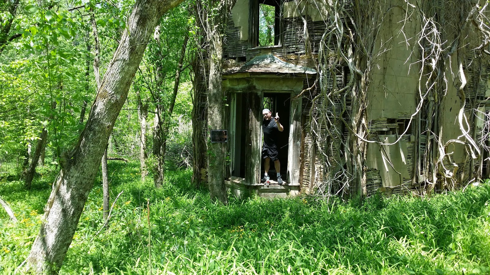
Little did we know that 320 Sycamore
(It's a Wonderful Life) would be on
the New River Trail in Austinville, VA
We found a cool old house right next to the trail that looked a lot like 320 Sycamore. George Bailey's house in the movie, It's a Wonderful Life. If it was later in the year, we likely would have missed this unique structure covered by leafy vines .  Chris had to go in and check it out. 


Chris gives an Ernie Bishop thumbs-up
after touring 320 Sycamore. George and
Mary can move right in just like the movie
After 50 miles of riding a beer and steak at the Blue Door Cafe,
Darper, VA was a perfect spot to refuel and  rest the legs and
rearrange the butt muscles. This place gets my highest rating.
After finishing the New River Trail, we loaded up and headed for Virginia Beach. It was late so we got a room in Richmond, VA, two and a half hours short of the False Cape State Park, and crashed and burned. 


Sunday, March 16, 2014

OUCH!!! Supreme Court does a supreme number on Rail Trails


Justice Breyer(middle) must have bonked his head
with one of his 3 bike accidents. How else could he
conclude an 1875 act and a 1942 decision is
applicable today? Justice Sotamayer was the only
legal beagle to rule in favor of the Trail folks like me.
Who would have thunk it? The U.S. Supreme Court (USSC) went back to a 1875 act and a 1943 decision to rule in favor of Marvin M. Brandt, a landowner in Wyoming. Sometime after 1875, Brandt's ancestors made a deal with U.S. Government to allow a railroad line to be cut through Brandt's property. Once the railroad finished using the right of way, the land was abandoned which was supposed to revert back to the landowner. Trail enthusiasts and governmental entities recently planned to extend the Medicine Bow recreational trail on this right of way. Mr. Brandt and the U.S,Supreme Court now say---no way, Jose! Although at first blush it appeared the USSC decision would be crippling, in retrospect it appears the decision is narrower than reported by the press, especially for those states east of the Mississippi River and trails where rights of way were either sold to the railroad or "railbanked".  

Therefore my trails only cross country goal does not appear to be in jeopardy; even though, the anti-trail rednecks will have another excuse to bitch at me for crossing or paralleling "their" road. When you are in red-neck country, A-holes will shout out or blare their horn at cyclists  like me. It happens too often. In defense of the red-necks, there are bikers that ride in groups that take up too much of the road and refuse to move over for traffic. I too have been pissed at these characters that not only hog the road but swear at the vehicles that wish to pass---especially those cyclists that ride a street or road juxtaposed to a bike trail only a few feet away.  Although I am riding 99% bike trails, there are times, for example where I needed to by-pass the flooded Blue Ox/Voyager Trail. That time I had to ride about twenty miles on a wide foot shoulder of Highway 71, giving a red-neck the opportunity to blast me with his ear splitting truck horn. 

Winter is just now starting to release its power grip on the midwest with some forty degree day time highs. March winds in the 20's still makes the "feels like" temps are too low for comfort. I have toughened up enough to unhook my bike from the trainer and get out on some rides. Believe it or not it is supposed to get into the fifties and low sixties in a couple of days. I have my fingers crossed I can get in a 30 miler soon. It's riding time even though we can get some snow in April.   


Thursday, February 20, 2014

Cabin Fever In Iowa

After backing the car out of the garage, I use this trainer to
pedal while listening to PRI jokester Michael Feldman. 
This has been a tough winter. Tougher than I have experienced since the farm boy days. The last few weeks have had me climbing the walls with "couped upiness". So it seemed like a good idea to clear my noggin, get some exercise and train my gluteus maximus to receive a hard seat come traversing America time. After all I haven't done any pedaling since the pre-Xmas rides in South Carolina. My guess is I thought I had burned up enough calories on the Swamp Fox Trail. and wore down my tailfeathers adequately,  to take off a couple months---Off your butt, slacker Maze! So, off to the garage I have gone. As much I hated going to Gold's Gym to pump it up on stationary bike in 2005; prepping for a Mt. Everest Base Camp trek in Nepal, I have now relinquished my resistance to spinning to nowhere and purchased a bike trainer. Hence I have been riding in one spot for thirty minutes, three to four times a week. The garage isn't the most toasty spot in the winter months, most often just above freezing, but I am making progress with the butt and legs. I plug into my I-pod and spin away, listening to Michael Feldman's Whad'ya Know?( I listen to him on the trails too ). One spot in the garage doesn't replace the sights alone rail trails but it has established sufficient mind clearing exercise, segwaying away from record cold and snow outside. In addition, I am using my STAFGD (Smarter than a fifth grader) device (Samsung Note 3) and discovering I can listen radio station broadcasts across the nation. For example,  I can listen to Jimmy Kimmel Live---my replacement for Jay Leno . There are so many tricks and applications these midget computers can do yet  I wonder if I will ever learn enough to say I am smarter than a fifth grader. So far I have been shocked at how smart my  STAFGD truely is. Often it seems to read my mind.

The past two winters, I have perused Google Earth, Google Maps, Trail-Link, state park websites and the Department of Natural Resources (DNR) of half the states of this country, locating trails that cross every degree of latitude. Since my goal is to avoid roads and highways, it has been tricky trying to locate trails that would meet self-imposed criteria (see my first post nearly two years ago) and eventually cover the USA from the Canadian to the Mexican border. Just a few days ago I just finished planning the last trail to traverse the country from 48.60777 to 32.53446 degrees parallel. I have found eighty-five trails in twenty-two states to accomplish this cross country feat. It is a lengthy process to identify a trail, assess the its elevation and rideability and then draw a line down the trail. I figure by the time I find a workable trail and then click the computer mouse every few miles along the route, I invest three to four hours to plan a trail ride. For eighty-five trails that amounts to nearly three hundred hours at the computer. All latitudes must overlap each other. Sometimes I discovered I could only get an overlap of latitude by riding city streets, sidewalks and bicycle friendly roads. I consider bicycle friendly roads or streets to be ones where the speed limit is 45 mph or less and a shoulder at least three feet wide or more. UTube has been very helpful in giving me a preview of a trail. At this point an interesting fellow with the pseudonym "XtremeKatfishn", wins my UTube Oscar for his video coverage of the Swamp Fox trail. As tough as the December 2013 ride was for me, his mile by mile  images and reports of the Swamp Fox spared me added frustration of not knowing the trail named after Francis Marion, was not a friendly bicycle trail. Katfishn helped me see there were going to be some rough spots. Unfortunately not many UTube reports contain the detail that  XtremeKatfishn provided. So for each trail planned, I must do considerable research to try to find out what the trail offers in terms of surface characteristics, unfinished or "washed out" bridges, availability of drinking water, trail head locations, elevations etc era. I am very thankful for what I have been able to decipher from the internet. Another information source I use are bike shops that reside in proximity of the trail. Depending who is working at the shop and the distance from the trail to the shop, I have learned next to nothing or quite a bit. For example, some shops know that a bridge is out, trees are down or something as mundane like why the trail was so named. Other shops tend to "kiss me off" with a curt remarks such as---"never heard of it"or "call the DNR"
The orange lines are trails I have ridden,. Green are planned, to be ridden trails. The longer the trail the easier to see on
the map above. There are a string of trails to be ridden along the California coast, Santa Barbara to San Diego and
numerous shorter trails in Utah, New Mexico, Arizona and Texas. A trail needs to be thirty miles or more to show on
this map.
If all things go as planned, Chris, Geoff and I will do another MBBR (Maze Boy Bike Ride) in Virginia May 7-12.

While I wait out the winter, I will fine tune the three trails planned to assure they meet necessary latitude criteria and watch the birds and furry critters out the window. We get forty to fifty feathered friends and a half dozen mammals stuffing themselves with various varieties of  bird feed. Unfortunately the deer "pig out" on feather food to the tune of disseminating the feeders two to three times a week. I now fill the feeders less than half full to keep within our wildlife budget. We used to feed them corn, but the price is ridiculous---a side effect of ethanol production . The racoons, ground hog and opossum clean up seeds on the ground but the squirrels have 'figured out' a way to shinny up the one inch pole holding the feeders. Although the deer are usually nocturnal, occasionally they will roam through the property in the late afternoon. Here are some of the creatures that have come out during the day.
One of many fox and grey squirrels that
compete for the bird food. Luckily this
guy can't make it up the narrow pole. It's
fun to see him shinny half way up and
then do fireman's pole slide to the ground.
 Sometimes I oil the pole for added
entertainment :-)
Olivia the back lot
opossum shows up
occasionally to annoy
the cats.
Ricky and his buddies have been a
nuisance for us when two years ago
they decided to live above the ceiling.
13 of them. At $50 a creature to remove
them, the nuisance factor doubled.
Ricky's little brother. Cute but a bother
none the less.