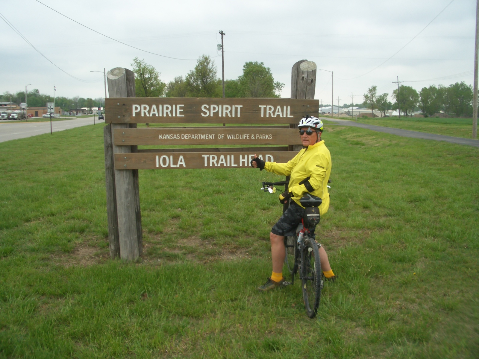
Wednesday, May 22, 2013

Maze Bike Ride Two (MBR2) Seg #16 5/10/13


Seg #16 Prairie Spirit Trail: 5/10/13 (MBR2)
 
Start
Humboldt, Kansas
N37.77661W-95.42931
N-S miles 35.4mi*

End
Garnet, Kansas
N38.28587-95.24903
Trl lgth 38.8mi Ride 43mi

It first looked like an easy ride. NOT!!!!

It was a short night in Iola, despite sleeping-in for an extra hour to give Geoff’s PDT(Pacific Daylight Time) body a little break. The weather report before I headed to Kansas forecast southwest winds and temperatures in the eighties. But that wasn’t the way it shook out on Friday morning. The temperatures were in the low sixties with a twenty mile per hour the northwest wind. Boo! Hiss! The hotel was only a few feet from the Prairie Spirit Trail (PST) which appeared to be a hard asphalt surface. No sooner had I rode less than a mile, the asphalt trail became a bumpy grass path formed by a vehicle or two using the trail for something beside recreation.  Once the hard surface trail ended, my predicted one hour ride was nixed and so was the idea that Geoff could meet me in Humboldt in an hour; instead I was in for a tough two hour ride. There were barricades placed at every point the trail intersected county roads, roughly a dozen orange fences to keep out hunters? 
I wasn't hunting---just went around such fences
After going through the first barricade, it was clear that new crushed limestone was being laid. This new surface was not as compacted as it needed to be. With recent rains and lack of compaction, this Maze Boy had a major workout riding a beach soft trail for nine miles. This type of trail saps one’s energy and lends itself to even more pokiness in achieving an one hour ETA.  It was 11:30 before I got to Humboldt. To meet Geoff at the proper latitude, I needed to ride south of Humboldt, a mile or two on a street that turned into a road. For a short stretch I was brushing shoulders with huge 50 ton concrete trucks pulling out of the Monarch Portland Cement Company. What a big operation for a small town! This is the first time since starting this journey that I had to ride a street that really didn’t qualify as a street or trail. Unfortunately I expect to find myself trapped into riding a road or highway once in a while. I hope not more than a mile or so. The goal is not to ride where vehicles are traveling above 45 miles per hour. When I got to 1200 Street and Connecticut Avenue, Geoffer met me and we threw my bike on the carrier, sequestered  a sandwich from the Iola McDonalds and then father and son rode north towards Garnet, KS. Geoff rode thirteen miles north and then turned around and rode twice as fast south with the wind at his back. With a stinky headwind, the three hour ride became a four hour and half hour ride just to make it to Garnet, short of my goal. I had eight more miles to reach the target latitude of 39.39997 near Richmond, KS. Since the Los Angeles Kings hockey team was playing the St. Louis Blues in the Stanley Cup Playoffs, and Geoff wanted to get to Chris’ house to watch the game (both my boys and their buddy Brian are huge hockey fans), therefore the last eight miles were shelved and we took off for Chris’ house in Runnells. Most of the route back to Iowa was interstate, so Geoff put the pedal to the metal (80+mph) to make the five hour trip a 4 hour trip. We missed the start of the game but caught all the goals and witnessed a Kings win to take the first round of the playoffs. Everyone at Chris’ house whooped it up, high fiving, back slapping and cursing with jubilation. I sat there a bit dumb founded by the antics of forty plus year old men. Next for the Kings is the San Jose Sharks. Will the Kings capture the Stanley Cup a second year in a row?  

Ian with Dad, Uncle and GPa. Fore
The next day was a major sleep in for all fellows at 8930 Vandalia Road. When we finally got moving, Chris, Geoff and grandson Ian took me mini-golfing. It was windy as heck so some of our putts required hitting a moving target. Ian won the back nine and his dad won the match. Ian is becoming a good golfer at age 13.

Tom as in “Got Tom” aka “Got Milk”
Niece/Cousin Maia, graduated from Iowa State University on Saturday. A geneticist no less! We joined Maia and her family for a nice meal at Aunt Maude’s in Ames. A few days later, Connie and Tom visited the graves of family members in Norway, West Amana and Watkins. Connie gave Tom the "Got Tom"tee  shirt Geoff brought from California.


25 year hiatus. This year made up for it!
May 12th was a special Mothers Day for Connie. Chris and Geoff were home for the day for the first time in twenty-five years---1988. MBR2 didn’t go as smoothly as MBR1 but the family fun associated with it, really made this a very special week.

Maze Boy Ride #2 (MBR2) Little Blue Trace Seg #15


Seg #15 Little Blue Trace: 5/9/13 (MBR2)

Start
Lee’s Summit, MO
N  39.14915W-94.31562
N-S miles 9.1*
End
Raytown, MO
N   39.00784W-94.17176
Trl lgth 16.1 Ride 32.3mi

 
One year ago, Chris, Geoff and I were ferried over to Anniston, Alabama to complete the Chief Ladiga-Silver Comet trail. This was Maze Boy Ride #1 (MBR1)The original plan for MBR2 was for me to bike one way and Chris and/or Geoff to ride roughly half way and then ride back to the car and drive to pick me up at the trail's end. Once it was clear that Chris could not participate in MBR2; he was still suffering from hernia surgery just two days prior, he had to stay home to recuperate. The good thing was the hole in his stomach muscle was small enough that repair could be done with suture alone---no mesh or other devices needed.  So I did another rain pounding drive with nasty trucks to Lee’s Summit, Missouri. By the time I reached the Iowa-Missouri border, the rain had let up and clear skies appeared for the rest of the day.

The Little Blue Trace Trail follows the course of the Little Blue River for 11 miles through the Little Blue Trace Nature Reserve. The trail serves as recreational and commuting trail for residents in the Lee’s Summit and Raytown, Missouri suburban communities east of Kansas City. I think my dyslexia lead to a two hour delay in finding the northern trail head.  Dixie, as I fondly refer to my GPS co-pilot, tracked my coordinates to an area of Rednecksville in the boonies. She kept me going to areas where all she could say was; “You are currently in an area where step by step directions are unavailable. Follow the arrow on the screen”. Well Dixie, that does not help when there arrow doesn’t appear to point to anything. So when I ended up in an area where NRA, No Trespassing, Keep out and other uninviting signs populated ever fence, gate and pole, I knew I must be in the wrong area. But just for spite I decided to get out of the car and inspect the small print below the “Keep Out” sign. I was sure the gate was put barricading the trail. As I read the fine print stating, “And this means you”. A wiry old codger pulled up in his rusted-  out Buick LaSabre with one bent wiper. “Hey” he said with a gap tooth grimace. “What ya doin’ har?” “Looking for the Little Blue Bike Trail I said”. “Aint nar bike tray rund har---all private prop”. After a few apologies from me, he started gabbing about the weather, where I was from and so on. I decided he enjoyed having someone to chat with so it was hard to excuse myself. I slowly eased myself back on the road, with him chatting the whole time. I could still see his lips moving in my rear view mirror a hundred feet down the road.
Using maps and asking folks, two hours later I finally found the northern trail head of the Little Blue Trace.  What beautiful setting especially in the spring time. The trail is mostly paved paralleling the Little Blue River. The lush grasses were an unusually velvet green, almost cloud-like. With large bright yellow patches of the wild mustard and bunches of purple radiating from the wild phlox beneath the trees, the scene was set for a beautiful ride.
 
Some of the beautiful wild flowers found along
the Little Blue Trace Trail in NW Missouri
Since I took so long to find this trail, I decided I would not have time to drive another hundred miles south to ride the Frisco-Highline Trail near Springfield, Missouri. So Inside of hiring a cab to get back to the trail head, I decided to ride sixteen additional miles back. I had time to kill waiting for Geoff’s Kansas City flight to touch down from LA. It was a good workout and enjoyable. Geoff’s flight was delayed until 10:30 CDT. That made for a late drive to Lola, Kansas. I was glad Geoff was not as tired, it was 8:30 for him, and was willing to drive. I hate driving at night. It was 1 a.m. by the time we hit the rack, making for a short night.

Friday, May 3, 2013

Best Made Plans:

Winter has been too long this year; in fact it has gobbled up a chunk of spring already. Less than a hundred miles northwest of Coralville, it snowed thirteen inches in Osage, Iowa and southeast Minnesota was hit with 15.7 inches, both all time records of the pretty yet annoying fluff.

light dusting (15+ inches) of snow on the deck furniture
in Wisconsin

Due to the cold rainy weather my plans for today, planting flowers we bought yesterday from the Amish in Kolona, has been put on hold, along with training rides for the 2nd Maze Boy Ride (MBR-II) next week.

Poor Chris popped a hernia a couple weeks ago and has repair surgery scheduled May 7th, just two days before the MBR-II. We are thinking that bike riding will be out of the question for Chris so Geoff and I will ride the three Missouri and Kansas trails on the schedule. Hopefully Chris can drive the car, dumping us off at one end of the trail and picking us up at the other end. I will post the outcome of the MBR in a couple weeks. In the meantime I can try to make sense out of derailleur adjustments videos on U-Tube. I can see why bicycle mechanics did not go into teaching or maybe it’s the student?!

Monday, April 15, 2013

Bentonville (Waltonville) Trails Seg 14


Seg #14 Bella Vista/Bentonville (“Waltonville”) AR Trails: 4/9/13

Start

Bella Vista, AR

N  36.43361W-94.22905

N-S miles 9.9*

End

Rogers, AR

N   36.29126W-94.17176

Trl lgth13.6 Ride 27.5mi

 
It was after three o’clock before I got to Arkansas and the North Bentonville Trailhead. The ducks by the lake were in a row---a good sign for me to squeeze in most of my trail riding before dark.
    
 It didn’t take long before I realized that although the town was named Bentonville, it was really Waltonville, as in Sam Walton, the founder of Walmart. I am certain he dumped tons of money into this area. Apparently in the early days he intrigued enough locals to invest in his enterprise, which led to many a millionaire in the Bentonville area. The whole area is neat, clean and upscale. The downtown has been restored and is loaded with fine shops, restaurants and theatres. The high school appears to have everything a college campus would boast. There is an indoor practice facility and stadium that puts most FCS and some BCS colleges and universities to shame.
 
The Crystal Bridges Museum of American Art is a beautiful building filled with historical, contemporary and modern American art. The bicycle trail runs through sculpture gardens behind the museum.


Alice Walton, Sam’s daughter, is the
major benefactor of this 220,000
square foot building and grounds
surrounding Crystal Bridges museum.
A Place Where They Cried commemorates the
Native Americans that perished during the forced
migration/"relocation" under Andrew Jackson in
the 1880's (see Post # 1 Maiden Ride Epilogue)
The Trail of Tears commemorative display below reminded me of a mini Stonehenge in England. Connie and I attempted to go there when I was on R &R while with the US Air Force in the Azores, Portugal. Problems with train connections prevented us from getting to Stonehenge but years later Connie got there with her mom.    
There are many other pieces of sculpture on the museum grounds, from a life sized pregnant sow to Roxy Paines’ incredible stainless steel tree entitled Yield. Crystal Bridges is the first major art museum built since 1974. It’s a trip worth taking. I hope to take Connie there when I head to Oklahoma to do Tulsa and Oklahoma City trails.

Mazer gives a Thumbs Up for
Yield by Roxy Paine
I ran out of daylight so found a motel and I finished off the last ten miles of the Bentonville ride Tuesday morning. It had rained all night and threatened to do so in the morning but other than a few sprinkles, I escaped the down pours that crashed on me just after pulling out of town. I don’t like driving at night, in the rain and especially at night in the rain. The only good thing was it was daylight most of the way back to Coralville. But, the pitchfork and hammer handle downpours coupled with pea soup fog, limited visibility to a few hundred feet, particularly when a huge semi-truck came whizzing past.  Damn those guys!

Nine and a half hours later, I was back in Coralville bushed but no worse for wear except for my sore ribs :-(